How we detect and map biomass loss in tropical forests can play an important role in conservation efforts. However, unlike large-scale deforestation, small-scale disturbances are often difficult to pinpoint and quantify. New analysis, led by CMCC researcher Chiara Aquino, helps improve our ability to monitor selective logging and in the process understand and manage the health of these vital ecosystems.
As industrial logging, fires, and agriculture driven by commodity markets continue to increase and threaten the resilience of forests, there is a growing urgency to find effective ways of monitoring forest loss.
Although large-scale deforestation and forest clear-cuts can often be picked up with moderate resolution (30–250 meters) satellite imagery, small-scale disturbances such as those caused by selective logging – which involves the targeted harvesting of specific and often high economic value trees – are often difficult to detect, especially in dense forest canopies.
A new study, led by CMCC researcher Chiara Aquino and funded by the University of Edinburgh, helps improve the way in which we map small-scale damage to tropical forests. The research combines satellite data and on-the-ground measurements to identify the best method for tracking biomass loss in tropical forests.
“By improving our ability to monitor these changes, we can better understand and manage the health of these vital ecosystems,” says Aquino. “This research stresses the need for accurate and reliable data to calibrate remote sensing measurements. Without direct knowledge of the forest conditions, we cannot effectively interpret the satellite data or identify the most appropriate methods for detecting changes on the ground.”
The study uses unique datasets gathered from direct measurements of selective logging, using terrestrial laser scanning to create detailed 3D images of trees and standard forest inventory methods. It then applies an analysis of six different satellite sensors to determine the best way to map small changes in biomass loss and uses a new approach to create a biomass loss map directly, instead of the traditional method of subtracting two separate biomass maps, which often introduces errors.

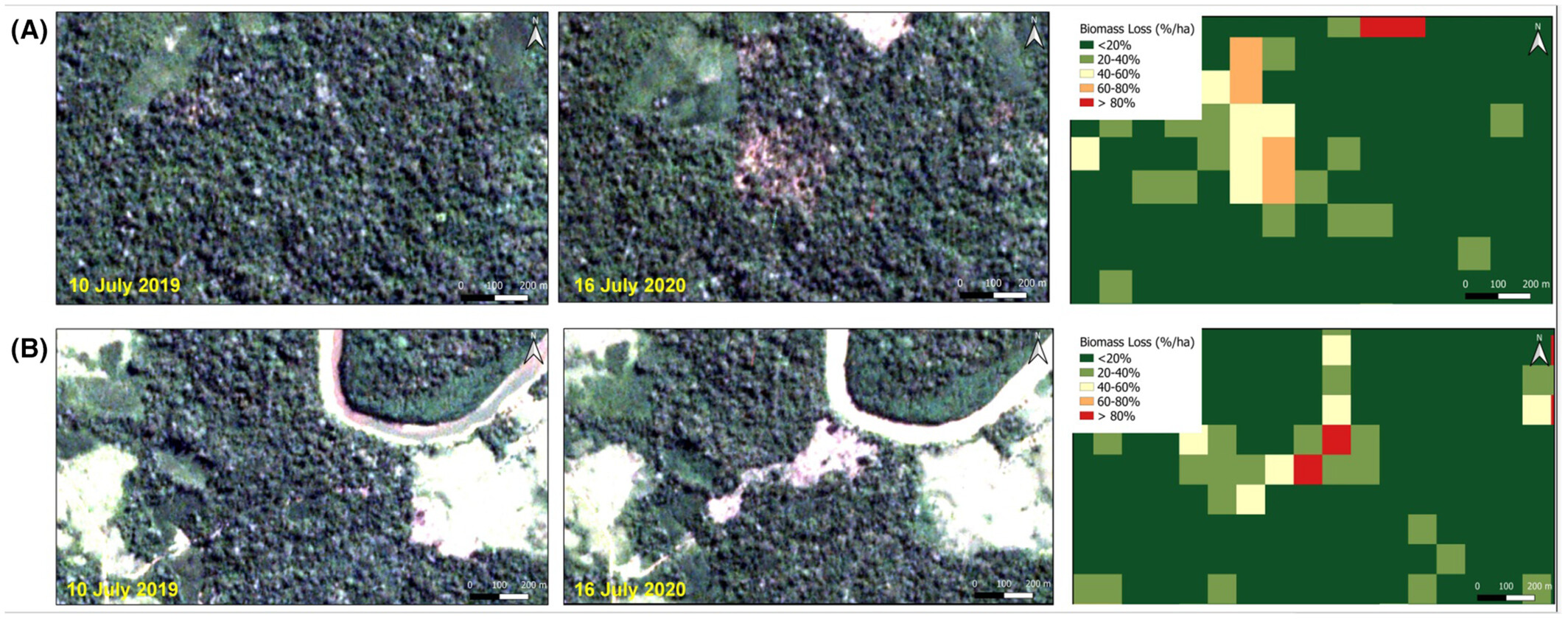
The figure above presents images from the PlanetScope satellite taken in 2019 and 2020 (left panel). These images illustrate forest biomass loss at two sites, one being converted into pasture (A) and the other into farmland (B). The right panel shows our biomass loss map, which effectively detects the changes in biomass in these areas. Source: Aquino et al 2024.
The research combines data from forest plots in the southern Peruvian Amazon, where the number of trees removed during selective logging and the resulting loss of biomass were counted and measured. This data was then compared to data obtained using six different optical satellite sensors to see which one was best at detecting these changes in forest structure.
“The main findings showed that the 3-meter resolution PlanetScope gave the best results and had a strong correlation with biomass loss,” says Aquino. “We also discovered that using the texture measure of the Near-InfraRed (NIR) band was more effective for tracking biomass loss than traditional spectral analysis. Overall, this study suggests that for detecting low to medium intensity disturbances in lowland Peru, using texture measures from PlanetScope data is the most effective approach.”
Despite global efforts, including many countries committing to the 2030 zero deforestation pledge at UN COP26, deforestation rates in 2023 are still more than 45% above the target necessary to achieve this goal.
“Mapping forest carbon clearly won’t halt deforestation. We must dive deeper to understand the processes at play on the ground and the economic factors fueling forest change worldwide. At the same time, we also need to develop reliable and replicable methods for detecting these changes, by collecting high-quality and reliable field data to train our algorithms,” says Aquino.
For more information:
Aquino, C., Mitchard, E.T.A., McNicol, I.M., Carstairs, H., Burt, A., Vilca, B.L.P., Mayta, S. and Disney, M. (2024), Detecting selective logging in tropical forests with optical satellite data: an experiment in Peru shows texture at 3 m gives the best results. Remote Sens Ecol Conserv. https://doi.org/10.1002/rse2.414


