On June 1-2, 2015, the project meeting about the risk assessment of a long-term planned geological repository for nuclear spent fuel took place in Olkiluoto nuclear power plant site (Finland, Figure 4). This meeting was organized in the framework of the climate service that CMCC is providing since June 2013 to the Swedish Nuclear Waste Management Company (SKB) and to the Finish Nuclear Waste Management Compagny (POSIVA) more recently. The meeting involved a panel of engineers and geologists from POSIVA and few climate and ice-sheet modelers from SKB, from the Finish Meteorological Institute and from CMCC.
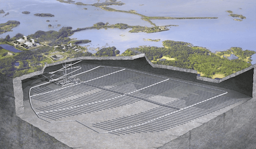
The storage of nuclear wastes and nuclear spent fuel is a critical issue from economical, social and environmental point of view. After several decades of investigations, the Swedish and the Finish Nuclear Fuel and Waste Management Compagnies, SKB and POSIVA, submitted an application for a permit to build a planned geological repository for spent nuclear fuel close to the Forsmark nuclear power plant (South East Sweden) and to the Olkiluoto nuclear power plant (West Finland). Those underground repositories will be dug at approximately 400 to 500 meters of depth, in the Scandinavian bedrock (Figure 1). The nuclear spent fuel will be encapsulated in copper canisters, buried in the gneiss/granitic bedrock and sealed off with bentonite clay (Figure 2).
The main goal of those burring techniques is to safely store the nuclear spent fuel for at least 100,000 years, decaying time for which the nuclear wastes radiations drop below natural radioactivity levels.
To better assess the mechanical and environmental constraints that those underground repositories would experienced through time, the Swedish and Finish authorities commissioned a risk assessment report spanning the next 100,000 years to POSIVA and to SKB (up to the next 1 million years) and exploring various aspects, from infrastructure mechanical behavior to climate changes. From climate changes perspective, projecting the climate evolution over the next million years is a complex exercise. While the evolution of the Earth’s orbital configuration (determining the amount of insolation over latitudes) can be calculated from astronomical solutions, the evolution of the long-lived atmospheric CO2, CH4 and H2O concentrations cannot be determined without the use of climate models. In addition to model uncertainties, the anthropogenic impact on the natural climate variability nowadays and in the future is hardly constrained. For this reason, SKB and POSIVA proposed to test the impact of different environmental changes scenarios, spanning a large flooding caused by global sea-level rise (warm scenario) to the full glaciation (cold scenario), on the underground repositories.
In this context, SKB contacted CMCC in April 2013 to ask for an expertise about the impact of an extensive glaciation on the Forsmark repository. This extensive glaciation scenario is based on the penultimate glaciation that occurred over Scandinavia about 140,000 years ago (Svendsen et al., 2004, Figure 3). This glaciation is considered as the most extensive glaciation on records over Eurasia since the last 2 million years. The main objective of the first phase of this climate service was to provide an ensemble of ice thicknesses at the Forsmark site using a state-of-the-art ice sheet model (GRISLI, Ritz et al., 2001) and a coupled climate model (CESM, Gent et al., 2011). All the calculations were performed on CMCC supercomputer infrastructure located in Lecce (South Italy).
In total, about 150 ice-sheet simulations were carried out to investigate the impact of surface mass balance, climate forcing, ice-sheet basal sliding, ice shelves, geothermal heat fluxes and glacio-isostasy. Those, indeed, are the main processes directly affecting the ice thickness evolution. CMCC concluded that the simulated ice thickness over the Forsmark repository for the penultimate glaciation ranges from about 2600 meters to about 3500 meters. Due to the weight of the ice accumulating over the repository, the ice-sheet model calculated that the underlying bedrock is depressed to depths up to 800 meters. The detailed assessment study (Colleoni et al., 2014) is publically available for download on the SKB website.
Based on those results, a second phase, co-funded by POSIVA, started in December 2014. In this second phase of the climate service, CMCC was asked to provide an estimate of the penultimate glaciation maximum ice thickness over Forsmark (Sweden) and over Olkiluoto (Finland). The preliminary results were discussed during the aforementioned mid-project meeting that occurred last June 1-2 in Finland. During the meeting, the participants visited the low-level repository, built at 60 meters of depth, in the gneiss bedrock of the Olkiluoto site. This low-level repository is used to temporary store nuclear wastes during the building phase of the high-level underground repository (Figure 4).
In the next months, CMCC will achieve the climate service with SKB and POSIVA companies and a new meeting has been planned at the end of the fall, with a wider panel of environmental experts to discuss some of the implications of the climate and ice-sheet modeling results in the framework of the risk assessment of the Swedish and Finish repositories sites.
Project participants :
- Florence Colleoni (CMCC, Italy)
- Aurélien Quiquet (CMCC, Italy)
- Jens-Ove Naslund (SKB, Sweden)
- Jenny Brandefelt (SKB, Sweden)
- Anne Lehtinen (POSIVA, Finland)
- Lasse Koskinen (POSIVA, Finland)
[nggallery id=4 template=sample2]
Figure 1: from top to bottom, the Olkiluoto nuclear power plant (Finland), the entrance of the low-level repository nuclear wastes room, the storage room for the nuclear wastes.
Figure 2: sketch on the high-level underground repository that would be built in Forsmark (South East Sweden). Courtesy, SKB
Figure 3: example of copper canister filled with nuclear spent fuel at Olkiluoto Exhibition Center
Figure 4: Comparison between the Eurasian ice-sheet extent for the Last Glacial Maximum (21,000 years ago) and the Late Saalian glacial maximum (140,000 years ago). The ice extent are from Svendsen et al. (2004) and the benthic d18O data are from the SPECMAP project and are available at https://www.ncdc.noaa.gov/data-access/paleoclimatology-data


